

OR Portland
Bridlemile
Bridlemile is a hillside Southwest Portland neighborhood bounded by SW Beaverton-Hillsdale Highway, SW Terwilliger Boulevard, and SW Dosch Road, where mid-century ranch and split-level homes sit on lots ranging from 8,000 to 12,000 square feet. Marquam Nature Park borders the neighborhood to the east with over 180 acres of forested trails connecting to Council Crest Park, and Multnomah Village and Hillsdale each sit about 5 minutes away by car for full-service grocery and retail.





Living in Bridlemile
A low-traffic hillside neighborhood in Southwest Portland with mid-century ranches, large lots, and trail access to Council Crest and Marquam Nature Park.
Updated April 2026 by Joe SalingWhat Bridlemile Is Really Like
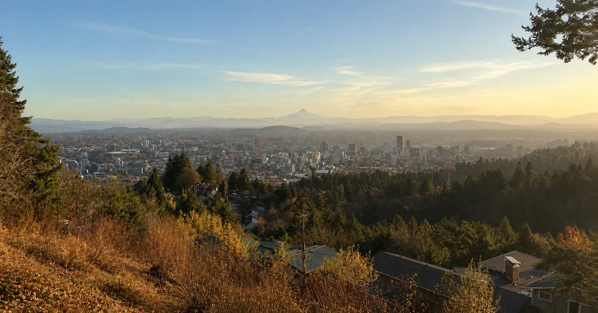
Bridlemile occupies a hillside position in Southwest Portland, roughly bounded by SW Beaverton-Hillsdale Highway to the north, SW Terwilliger Boulevard to the east, the Multnomah neighborhood to the south, and SW Dosch Road to the west. The terrain defines the neighborhood more than any commercial corridor: streets curve with the contour of the West Hills, most blocks dead-end into natural areas or slope sharply upward toward Council Crest, and the tree canopy is dense enough that aerial views look more like forest than suburb. Lot sizes run considerably larger than inner Southwest neighborhoods, which is the primary reason buyers start looking here when they want more land without leaving Portland city limits.
Weekday mornings bring the hum of SW Beaverton-Hillsdale Highway from the northern edge and the sound of neighborhood residents pulling out for the short drive to Barbur Boulevard or Terwilliger. The interior residential streets are set well back from the arterials, and by mid-morning the blocks between the parks go still. Weekend rhythms shift toward the trail systems: Marquam Nature Park trailheads are accessible from multiple entry points in and around the neighborhood, and Council Crest Park sits just uphill with its paved summit loop and views of four Cascade peaks on clear days. Birch Community Services and Wilson High School on the eastern edge of the district draw weekday traffic, but Bridlemile itself sits behind those corridors rather than on them.
On residential blocks you will see people tending larger gardens, running the Marquam trail network, and commuting by car to Hillsdale, Multnomah Village, or downtown. The neighborhood has no commercial businesses within its own boundaries; Multnomah Village sits about 5 minutes south by car and Hillsdale is about the same distance north, both offering full-service grocery, restaurants, and hardware. Residents drive for everything beyond trail access, which is the honest trade-off this neighborhood presents and also a key part of its appeal to buyers who want a lower-density residential block with room for gardens, outbuildings, or simply more space between houses.
Looking for broader context on the area? Read my full Southwest Portland relocation guide for how Bridlemile fits into the wider district.
Homes and Architecture in Bridlemile
Bridlemile's housing stock is dominated by mid-century construction, with most homes built between the late 1940s and the early 1970s. Ranch-style single-story homes are the most common form, often with attached garages, low-pitched roofs, and wood or brick exteriors. A secondary layer includes split-level homes from the 1960s, which use the hillside topography to create two or three finished levels without the visual height of a two-story. Lot sizes are a defining feature here: most parcels run 8,000 to 12,000 square feet, and some larger irregular lots exceed a quarter acre. A small number of newer custom homes occupy infill lots or scrape-and-build sites, but the neighborhood's overall character remains mid-century.
When you shop in Bridlemile, expect a wider range of condition and update level than you would see in a more urban Southwest neighborhood. Some homes have been significantly updated by long-term owners over the decades; others retain original 1950s and 1960s systems, kitchens, and baths. Because the neighborhood draws buyers specifically for the lot size and trail access rather than move-in-ready finishes, listings here negotiate more than inner-ring Portland neighborhoods, even in competitive markets. Two items to include in your due diligence: oil tank decommissioning records (mid-century SW Portland homes commonly had underground oil tanks; always pull the DEQ UST lookup and request records), and septic-to-sewer conversion status on older properties that may still be on private systems in the hillside areas.
- Mid-century ranch
- Split-level
- Custom infill
- 8,000 to 12,000 sq ft lots common
- Mid-range for Southwest Portland
Geography, Amenities, and Getting Around
Council Crest and West Hills Terrain
Bridlemile sits on the upper western slope of the Tualatin Mountains, with Council Crest Park (1,073 feet elevation) bordering the neighborhood to the northeast. The varied terrain creates blocks with significant elevation changes, territorial views of Mount Hood and Mount St. Helens from upper streets, and the kind of tree canopy density that makes the neighborhood feel far more removed from the city than the map distance suggests. The topography also means most streets curve and dead-end rather than forming a grid.
Multnomah Village and Hillsdale
Bridlemile has no commercial businesses within its own boundaries. Multnomah Village, about 5 minutes south by car on SW Multnomah Boulevard, offers a full-service grocery (Safeway), restaurants, a hardware store, and a walkable main-street corridor. Hillsdale, about 5 minutes north along SW Beaverton-Hillsdale Highway, provides a New Seasons Market, pharmacy, and additional retail. Most residents choose between the two hubs based on the specific errand.
Marquam Nature Park
Marquam Nature Park borders Bridlemile on the eastern edge with over 180 acres of forested hiking trails connecting to the 40-Mile Loop and Council Crest Park. Multiple trailheads are accessible within a short walk from interior Bridlemile streets. The park's trail network links to Duniway Park and the South Park Blocks trail system heading north, making it one of the more connected green spaces in Southwest Portland for residents on foot.
Getting Around
Bridlemile is primarily car-dependent for daily movement. SW Barbur Boulevard, reached in about 3 minutes, carries frequent TriMet bus service (Line 12) to downtown Portland in roughly 20 to 25 minutes. Drivers reach downtown via Barbur or SW Terwilliger in 15 to 20 minutes off-peak. I-5 access is approximately 5 minutes east. The neighborhood has no direct MAX service; the nearest light rail is at Washington/SE 12th on the Green and Orange lines, requiring a transfer from Barbur bus service.
Joe's Take on Bridlemile
Bridlemile is the neighborhood I put on the list when a buyer specifically wants more lot for the money in Southwest Portland without leaving city limits. The honest trade-off is straightforward: you are driving for every errand. There is no coffee shop around the corner, no grocery within walking distance, and no bus stop in the heart of the neighborhood. What you get instead is a larger-than-average lot, low-traffic residential streets, trail access into a 180-acre nature park, and a hillside position that gives upper blocks territorial mountain views. For the right buyer, that trade is easy. For anyone who wants daily walkability, Hillsdale or Multnomah Village will serve them better.
The housing stock and location suit buyers who want single-level or split-level construction on a larger lot, value proximity to green space over commercial walkability, and are comfortable driving 5 minutes for groceries. The mid-century bones here are generally solid, but these homes carry the inspection items common to their era and their hillside setting. A well-priced Bridlemile home in good structural condition can offer substantially more land than anything comparable in Hillsdale or Multnomah Village at the same price point.
Before writing an offer in Bridlemile, build in time for a few specific checks. Pull the DEQ Underground Storage Tank lookup for the address at deq.oregon.gov; oil-fired heating was standard in SW Portland mid-century construction and decommissioned tanks that were never remediated can create title and lending complications. If the home is on the upper slopes, request documentation that the property is connected to city sewer rather than an older septic system. Also check the specific Wilson High School boundary at pps.net: Bridlemile falls in the Wilson attendance zone, but Portland Public Schools boundary changes have shifted some Southwest addresses in recent years, and verifying for your specific address before writing is worth the five minutes.
Frequently Asked Questions About Bridlemile
How do home prices in Bridlemile compare to the rest of Southwest Portland?
Bridlemile prices sit in the mid-range for Southwest Portland, typically below the Hillsdale and Council Crest premium blocks but above lower-density outer SW neighborhoods. The larger lot sizes often mean buyers get more land per dollar than in Multnomah Village or the SW Hills proper. Homes with updated systems and usable outdoor space on the upper streets with territorial views tend to carry a premium within the neighborhood. The current average sales price and active listing count are displayed at the top of this page and update automatically with the market.
What are property taxes like in Bridlemile?
Multnomah County property taxes in Bridlemile run at an effective combined rate of approximately 1.3% to 2.1% of assessed value, consistent with the rest of the county. Oregon Measure 50 caps assessed value growth at 3% per year, so long-held homes frequently pay well below what their current market value would imply. Verify current rates and the specific assessed value for any address you are evaluating at multco.us/assessment-taxation.
Which schools serve Bridlemile?
Bridlemile is served by Portland Public Schools. The default elementary assignment is Bridlemile Elementary School, which serves the neighborhood and draws strong parent engagement scores on GreatSchools and Niche. Middle school students typically continue to Robert Gray Middle School and high school students to Wilson High School, one of PPS's larger comprehensive high schools. Use the PPS boundary finder at pps.net to verify the specific assignment for your address, as boundaries can and do change.
What is the housing stock like in Bridlemile?
The dominant housing form is mid-century ranch and split-level construction from roughly 1948 through the early 1970s, on lots running 8,000 to 12,000 square feet. Most homes are single-family detached with attached garages, and many have been updated over the decades to varying degrees. Marquam Nature Park borders the neighborhood on the east with 180-plus acres of forested trails connecting to Council Crest and the 40-Mile Loop. The upper streets have territorial views of the Cascades on clear days.
How long is the commute from Bridlemile to downtown Portland?
Downtown Portland is typically 15 to 20 minutes by car via SW Barbur Boulevard or SW Terwilliger Boulevard outside of peak hours. Peak-hour drives along Barbur can stretch to 30 minutes or more. TriMet Line 12 on Barbur (reached in about 3 minutes by car from most Bridlemile addresses) runs frequent service to downtown with stops at Barbur Transit Center, where riders can connect to other lines. There is no direct MAX service from Bridlemile.
Is Bridlemile walkable?
Bridlemile is not a walkable neighborhood for daily errands. There are no commercial businesses within the neighborhood boundaries, and the hillside terrain makes many routes to adjacent corridors steep. Walk Scores in Bridlemile are generally in the 20s to 40s depending on proximity to SW Beaverton-Hillsdale Highway. The outdoor walking picture is strong: trail access into Marquam Nature Park and toward Council Crest is available within a short walk of most interior blocks. Bike commuting on the hillside is challenging due to grade.
How does Bridlemile compare to nearby Southwest Portland neighborhoods?
Bridlemile sits between Hillsdale to the north and Multnomah to the south in both geography and price. Hillsdale has a walkable commercial hub anchored by New Seasons and runs slightly higher per square foot. Multnomah Village has a distinct main-street character and more commercial density on SW Capitol Highway. Arnold Creek and Ashcreek to the south offer similar residential character at a slightly lower entry point. Bridlemile is the pick when the Marquam trail access, the larger lots, and the upper-slope positioning on the West Hills are the primary draws.
Can I add an ADU or short-term rental in Bridlemile?
Most Bridlemile lots are eligible for an accessory dwelling unit under Portland's Residential Infill Project rules. The larger lot sizes that characterize the neighborhood can make ADU placement more feasible than on tighter inner-Portland parcels, though steep grade on some properties may affect setback options and construction costs. Short-term rentals require a City of Portland STR permit; Type A permits require owner-occupancy. Verify ADU eligibility and STR permit requirements for your specific address at portland.gov/bds before counting on either use.
Thinking About Buying in Bridlemile?
I help buyers navigate Southwest Portland neighborhoods every week. Let's talk about what you need, what you can afford, and whether Bridlemile is the right fit.
Schedule a Free Consultation Or call Joe directly: (503) 910-7364Joe Saling · Saling Homes at eXp Realty · 10+ years serving Portland metro buyers and sellers
Saling Homes at eXp Realty is committed to the principles of the Fair Housing Act and Equal Housing Opportunity. Licensed in the State of Oregon. Information deemed reliable but not guaranteed. Verify all data independently before making real estate decisions.
MY BLOGS


MARKET TRENDS

HOUSING DETAIL
NEARBY SCHOOL & BUSINESS
4249 SW DOSCH RD, Portland, OR 97239
Single Family Home 3 Beds 2.1 Baths 2,212 SqFt
Listed by eXp Realty, LLC
4803 SW STONEBROOK CT, Portland, OR 97239
Single Family Home 4 Beds 3 Baths 4,080 SqFt
Listed by Keller Williams Realty Professionals6155 SW SEYMOUR ST, Portland, OR 97221
Single Family Home 5 Beds 4.1 Baths 4,401 SqFt
Listed by Keller Williams Sunset Corridor4726 SW PATTON RD, Portland, OR 97221
Single Family Home 4 Beds 3 Baths 3,463 SqFt
Listed by John L. Scott3625 SW 60TH PL, Portland, OR 97221
Single Family Home 5 Beds 3.1 Baths 4,782 SqFt
Listed by Coldwell Banker Bain3646 SW 50TH AVE, Portland, OR 97221
Single Family Home 3 Beds 3 Baths 3,137 SqFt
Listed by Cascade Hasson Sotheby's International Realty3320 SW 44TH AVE, Portland, OR 97221
Single Family Home 4 Beds 2.1 Baths 3,104 SqFt
Listed by Windermere Realty Trust4414 SW ELEANOR LN, Portland, OR 97221
Single Family Home 4 Beds 2.1 Baths 3,426 SqFt
Listed by Portland's Alternative Inc., Realtors4535 SW 54TH PL, Portland, OR 97221
Single Family Home 4 Beds 3 Baths 1,676 SqFt
Listed by Redfin4411 SW 63RD AVE, Portland, OR 97221
Single Family Home 4 Beds 3.1 Baths 4,239 SqFt
Listed by Cascade Hasson Sotheby's International Realty5702 SW SEYMOUR ST, Portland, OR 97221
Single Family Home 3 Beds 2.1 Baths 2,036 SqFt
Listed by Wise Move Real Estate3707 SW 52ND PL #7, Portland, OR 97221
Condo 2 Beds 1 Bath 1,102 SqFt
Listed by Windermere Realty Trust4004 SW SCHOLLS FERRY RD, Portland, OR 97221
Single Family Home 5 Beds 4.1 Baths 6,445 SqFt
Listed by Coldwell Banker Bain5716 SW HAMILTON ST, Portland, OR 97221
Single Family Home 5 Beds 5 Baths 5,456 SqFt
Listed by John L. Scott4200 SW 53RD AVE, Portland, OR 97221
Single Family Home 4 Beds 3 Baths 3,328 SqFt
Listed by Windermere Realty Trust6437 SW RALEIGHWOOD CT, Portland, OR 97221
Single Family Home 3 Beds 2.1 Baths 2,698 SqFt
Listed by Where, Inc4221 SW SELLING CT, Portland, OR 97221
Single Family Home 4 Beds 4.1 Baths 7,111 SqFt
Listed by Windermere Realty Trust4321 SW TERLYN CT, Portland, OR 97221
Single Family Home 4 Beds 3 Baths 3,495 SqFt
Listed by Cascade Hasson Sotheby's International Realty5833 SW LANE CT, Portland, OR 97221
Single Family Home 4 Beds 3 Baths 2,906 SqFt
Listed by Cascade Hasson Sotheby's International Realty4322 SW TERLYN CT, Portland, OR 97221
Single Family Home 4 Beds 3.2 Baths 4,428 SqFt
Listed by MORE Realty

Coming Soon
Commute Score
Coming Soon
Coming Soon
DEMOGRAPHICS
Population:
Density:
Households:
Gender
Coming Soon
Coming Soon
Coming Soon
Coming Soon

Joe Saling
joe@sellingpdxhomes.com